
Transformation methods (GDA94 - GDA2020)
There are three transformations between GDA94 and GDA2020 recognised by the Intergovernmental Committee on Surveying and Mapping (ICSM): A 7 parameter similarity (conformal) transformation, and two transformation grids.
These transformations are compatible with existing software. Both NTv2 grids are available in the NTv2 format from ICSM’s GDA Transformation Products and Tools website.
The conformal only transformation grid, often denoted ‘con’, is simply a grid representation of the 7-parameter similarity transformation. It contains the latitude and longitude shifts between GDA94 and GDA2020 for each grid node, based solely on the 7-parameter similarity transformation parameters.
The conformal and distortion grid, often denoted ‘cpd’ for conformal plus distortion, is designed to compensate for any known localised distortions present in the control survey networks of each state and territory in Australia (up to 0.3 m horizontally in NSW).
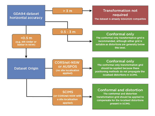
As a general rule, GDA94 data that is based on absolute positioning technologies such as CORSnet-NSW or AUSPOS should use the conformal only transformation grid, except when a site localisation has been applied to align it to SCIMS. GDA94 data that is based on SCIMS should apply the conformal and distortion transformation grid.
The following decision-making flow chart may guide NSW users in regard to which transformation grid should be used for existing GDA94 data of a particular accuracy.
Transforming 3D data (GDA94 - GDA2020)
3-dimensional GDA94 data can be transformed using the transformation grids provided, but only the latitude and longitude components will be affected, i.e. the height remains unchanged. If the height component is referenced to the Australian Height Datum (AHD), no height transformation should be undertaken between GDA94 and GDA2020 anyway.
The 7-parameter similarity transformation can provide a true 3D transformation for data with ellipsoidal heights, but will not compensate for localised distortions. The GDA2020 Technical Manual recommends users with ellipsoidal heights first convert their data to earth-centred Cartesian (XYZ) coordinates, apply the 7-parameter conformal transformation, and then convert back to geodetic or grid coordinates as required. The manual provides the formulae and a number of spreadsheets to perform these computations.
It is possible to apply a simple ‘block shift’ of -0.095 m to transform ellipsoidal heights from GDA94 to GDA2020, but each user will need to assess if this approximation is suitable for their datasets and applications. Across NSW, the ellipsoidal height difference from GDA94 to GDA2020 varies by just one centimetre, from -0.10 m in the north-east to -0.09 m in the south-west.
Overview of other transformation methods (AGD66 - GDA94)
High-accuracy transformation: AGD66-GDA94 Australian NTv2 distortion grid
In order to achieve the best possible spatial accuracy for any type of data, it is recommended that the Australian NTv2 distortion grid be used for all transformations between AGD66 and GDA94.
The absolute accuracy is about 0.1 m, but users should be aware that the relative accuracy between points over a small area will be maintained.
All the complex mathematical processing was done during the creation of these grid files, leaving your software to interpolate the required shifts and perform a simple addition to complete the transformation.
Many GIS and surveying software vendors have adopted the NTv2 grid transformation as a standard for their applications. Refer to the GDA94 Technical Manual for more information about this NTv2 grid.
To use this high-accuracy transformation, you will need to use the national or regional grid file covering your State or area. The files relevant to NSW can be downloaded here:
- National Grid file (PDF 3.3 MB)
- South East Australia - NSW and Victoria file (PDF 2.2 MB)
The national grid is also available from from ICSM’s GDA Transformation Products and Tools website. The grid files for other states may be downloaded from the websites of the relevent jurisdictions. Some states also have sub-grids which may be required for certain areas, and users should check for the existence of sub-grids with those jurisdictions.
Block shift
The block shift is a simple method of applying an average shift determined using one or more points with coordinates in both datums.
Average AGD66-GDA94 block shifts have been determined for all 1:250,000 map sheets across Australia, and these values can be obtained from the GDA94 Technical Manual. The accuracy of these shifts is limited to about 10 metres.
Molodensky's formula
Molodensky's formula uses an average origin shift and the difference in parameters of the two ellipsoids.
Formulae can be viewed and a spreadsheet for these calculations downloaded from the GDA94 Technical Manual. The accuracy of this method is limited to about 5 metres.
7-Parameter similarity transformation
The 7-parameter similarity transformation is a mathematical process that relates two datums by three origin translations, a rotation about each axis and a change of scale. This is a conformal transformation, which preserves the shape of the data.
The absolute accuracy of transformed AGD66-GDA94 data is in the order of 1 metre, but users should be aware that the relative accuracy between points over a small area will be maintained.
The following values are known as the Regional NSW / Victorian parameters and supercede the 'LIC93' transformation values for NSW:
AGD66 to GDA94 (NSW/Victoria)
| Parameter | Value | RMS |
| X axis Translation (metres) | -119.353 | ±0.08 |
| Y axis Translation (metres) | -48.301 | ±0.08 |
| Z axis Translation (metres) | 139.484 | ±0.08 |
| X axis Rotation (seconds) | -0.415 | ±0.03 |
| Y axis Rotation (seconds) | -0.260 | ±0.03 |
| Z axis Rotation (seconds) | -0.437 | ±0.03 |
| Scale (parts per million) | -0.613 | ±0.11 |
Note that two different conventions for rotation definitions are in use in the surveying industry: the position vector rotation (Bursa-Wolf model) commonly used in Europe, and the coordinate frame rotation commonly used in Australia and the USA. The only but important difference between them is the sign of the rotation parameters.
Refer to the GDA94 Technical Manual for other regional AGD66-GDA94 similarity transformation parameters or for the national AGD84-GDA94 parameters.
Whilst all effort is made to ensure the accuracy and currency of this information, Spatial Services does not accept responsibility for any actions arising from their use.
A 7-parameter transformation tool supporting AGD66 to GDA94 is available here.
More information and transformation tools
More information and resources:
- GDA2020 and GDA94 Technical Manuals
- ICSM GDA2020
- Spatial Services GDA2020
- Spatial Services Publications
Transformation and conversion tools:
- Geoscience Australia’s Geodetic Transformations and Conversions
- Spatial Services Conversion software
- ICSM GDA94 <> GDA2020 transformation tools
- Contact your software provider for software specific implementations.