
On this page:
- Introduction
- Topographic GeoPDF Maps
- How to download NSW Topographic Maps
- Copyright and terms of use
- Contact us
Introduction
DCS Spatial Services digital centric map series are available as self-service from the NSW Topographic Map viewer on our Spatial Collaboration Portal. The 2022 series offers enhanced cartographic representation of the earth’s surface features including:
- contours
- waterways
- roads
- buildings
- place names
- points of interest
- vegetation
- cultural features
- selected administrative boundaries
These maps are widely used across the community for bush walking, camping and recreational purposes, through to planning and development and are an essential tool for emergency services during disaster management and recovery.
Topographic GeoPDF Maps
The 2022 NSW Topographic Map Series is auto-generated accessing key current NSW Foundation Spatial Data Framework (link to FSDF webpage on website) data layer with auto generated text placement to provide terrain and key features within each map. The NSW Topographic Map series are georeferenced PDF format and ideal for use in GPS systems, smart phones and tablets and can also be printed under Creative Commons 4.0 licensing.
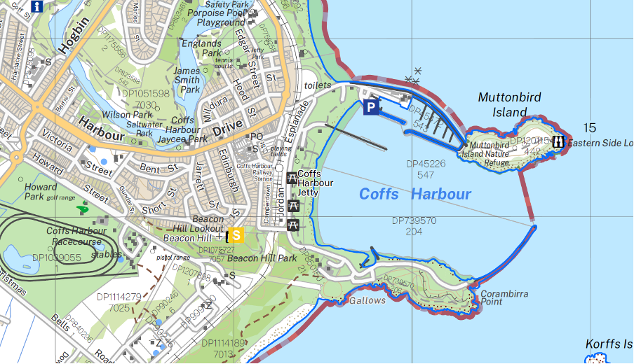
2022 Geo PDF – Coffs Harbour
How to download NSW Topographic maps
DCS Spatial Services offers NSW Topographic Maps as a free download from the Spatial Collaboration Portal - Select NSW Topographic Maps from the Map Viewers icon:
To download NSW Topographic Maps from the viewer:
- Select map name from the Topographic Map index
- Search address or map location using search tool
- Select the year and format
- Follow the steps to download
Features of the NSW Topographic Map viewer
- Map scales are typically 1:25,000 in the eastern region of NSW, 1:50,000 in the central region and 1:100,000 in the western most parts of the state.
- NSW Topographic Maps can be printed on any paper size. Maps can be reduced in scale to fit A3 or A4 for example and printed on your home office printer. Some output devices will offer the ability to tile the map output over multiple sheets while maintaining the original scale.
- Printing to scale (100%) will require a large format output device, typically available at printing stores and some retailers with a finished product size of 1135mm x 580mm.
- 2022 series - GDA2020 Compliance: The Geocentric Datum of Australia 2020 (GDA2020) is Australia’s new national datum, which replaces GDA94 in the previous GeoPDF map. GDA2020 is of higher accuracy than GDA94, aligns more closely with GPS and GNSS positioning services and supports nationally consistent datasets. Differences between GDA94 and GDA2020 (approximately 1.5 metres) are indistinguishable at the scale of these GeoPDF titles. Users should experience no change with their map usage based on the change of datum.
- Historical Map sheets of the state-wide series are available commencing 2011 and include 2014, 2015, 2016 and 2017.
- A ‘Collar off’ series (Collar Off maps have the same extent per title, without the legend and border allowing titles to be customised in TIFF format) is also available.
- Original map titles and identification are continued with the 2022 release.
Copyright and terms of use
DCS Spatial Services provide a range of datasets to private and government clients under Creative Commons licensing, in line with the NSW Government and NSW Department of Customer Service Open Data Policy. Read more about DCS Spatial Services copyright and licensing information here. By accessing any of the available Spatial Web Services you acknowledge acceptance of the Terms and Conditions.
Contact details
If you have any questions or feedback about our NSW Topographic Maps or require further information, please contact the Spatial Services Customer Hub.