
Spatial Services holds a wide range of aerial photography and other historical imagery of NSW for viewing. Aerial Imagery is captured across NSW and is available with a range of years from 1930s through to current.
Imagery from the past
Aerial imagery provides a valuable source of information for studying, monitoring, forecasting and managing natural resources and human activities. Obtaining aerial photos from different periods can be a useful way to research the history of an area or to verify different uses of land over time.
Free viewing and download of aerial imagery
The Historical Imagery Viewer, as part of the Spatial Collaboration Portal, allows users to search, discover and download historical imagery from our library, dating back to the 1930s. Users can search an area of interest, and look at thumbnails of each available frame and download a 600dpi version of a chosen image, free of charge.
Over Sydney, these images can also be viewed as a mosaic, allowing users to explore the city and its history.
Aerial Photography
The Spatial Services Imagery Capture Program has also captured more recent aerial imagery over NSW. This imagery can be viewed as a basemap on Six Maps or the Spatial Collaboration Portal.
Georeferenced and orthorectified photographs
To use imagery in a GIS, it is necessary to georeference or orthorectify the imagery. To georeference something means to define its existence in physical space, that is establishing its location in terms of map projections or coordinates. The term is used both when establishing the relation between aerial images and coordinates and also to determine the spatial location of other geographical features.
Orthorectification removes distortions due to height, altitude of the aircraft and the terrain that has been photographed. This allows precise measurement in line with the scale of the photography.
Elevation data
Spatial Services has access to specialised Radar, Light Detection and Ranging (LiDAR) data and satellite imagery which depict height information, vegetation, floods and other special conditions and features. Spatial Services contributes the NSW LiDAR imagery to the national data set, Elevation and Depth – Foundation Spatial Data (ELVIS).
This imagery can be useful to organisations involved in planning and managing land use and the natural environment.
Satellite imagery
Satellite imagery, designed to aid in management of resources and monitoring of oceanic and terrestrial changes, is available from Satellite Pour l’Observation de la Terre (SPOT 5), a system of satellites launched in 2002.
More recent satellite imagery is available as part of Spatial Services SPOT 6/7 mosaics. So far two satellite imagery mosaics have been captured at 1.5m resolution (from 2019 and 2020) as part of the Spatial Services Whole-of-Government initiative. The provision of this dataset was awarded by tender to Geospatial Intelligence Pty Ltd who has partnered with Geoimage Pty Ltd and Airbus Defence and Space. The imagery from this latest capture will be of particular use to agencies working on a range of change management initiatives. Used alongside our fourth quarter 2019 Spot Imagery release, monitoring urban expansion and land use/cover changes at a small, medium or large scale, to help better observe and understand the evolution of urbanisation and advance the sustainable development process are all achievable. Bushfire affected areas throughout NSW can be viewed prior to and post the devastating season experienced in 2020.
SPOT 6/7 Imagery 2019 can be viewed as a basemap on the Spatial Collaboration Portal. The 2020 capture will soon be available as a basemap via the Spatial Collaboration Portal. NSW Government agencies are also able to contact the Service Delivery team to request access to individual mosaics and state wide mosaics from 2019 and 2020.
In 2019/20, Spatial Services facilitated a Whole-of-Government daily satellite imagery subscription through Planet Labs. In 2020/21 this innovative service will be facilitated by the Department of Planning, Industry and Environment (DPIE). Existing registered users have been transferred to the DPIE subscription. Local and state government agencies who are interested in registering for this subscription can contact DPIE directly at Spatial.imagery@environment.nsw.gov.au.
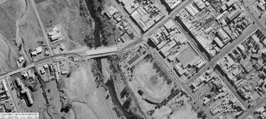
Tamworth historic imagery 1965
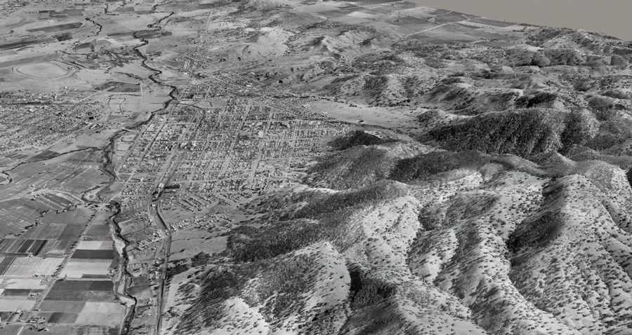
Tamworth historic imagery 1965 in 3D
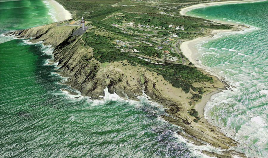
Byron Bay Light House looking south to Tallow Beach
This image is a 3D view from NSW Globe with some 3D buildings