
Listed below are map projections relevant to New South Wales. Scroll down to view details of the projection parameters and associated ellipsoids.
Our GNSS Publications contain several publications related to datums, transformations and projections. Additional information is available in the GDA2020 Technical Manual, on ICSM’s Australian Geospatial Reference System page and on Geoscience Australia’s Geodetic Datums and Projections page.
Current GDA Projections
- MGA - Map Grid of Australia
- GDA Lambert Projection for NSW
Superseded AGD66 Projections
- ISG - Integrated Survey Grid
- AMG - Australian Map Grid
Others
- UTM - Universal Transverse Mercator
- ANG - Australian National Grid (pre 1966)
- Lambert - NSW Mapping Agencies (pre GDA)
MGA - Map Grid of Australia (MGA94, MGA2020)
The official coordinate projection for use with the GDA94 and GDA2020.
| Projection: | Transverse Mercator |
| Zone: | Width: 6 degrees |
| Longitude of Origin: | Central Meridian of each zone |
| Latitude of Origin: | Equator (zero degrees) |
| False Easting: | 500 000 |
| False Northing: | 10 000 000 |
| Central Scale Factor: | 0.9996 |
| Units: | Metre |
| Ellipsoid: | GRS80 |
| More Information: | ICSM website. |
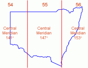
MGA Zones for NSW
GDA Lambert Projection for NSW (GDA94 Lambert, GDA2020 Lambert)
This Lambert projection is suitable for state-wide GIS data in NSW. To ensure uniformity across agencies, the Surveyor General has endorsed the following parameters for use with GDA94 and GDA2020 data.
| Projection: | Conformal Conic | |
| Standard Parallels: | -30º 45' 00" | |
| -35º 45' 00" | ||
| Latitude of Origin: | -33º 15' 00" | |
| Central Meridian: | 147º 00' 00" | |
| False Easting: | 9 300 000 | |
| False Northing: | 4 500 000 | |
| Units: | Metre | |
| Ellipsoid: | GRS80 | |
| More Information: | [Historic] Policy for GDA94 NSW Lambert Conformal Conic Projection (PDF 3.6 MB) | |
ISG - Integrated Survey Grid
A projection used in NSW only - ISG was introduced to minimise scale factor corrections (mainly in cadastral surveys). Coordinates are derived from the Australian Geodetic Datum 1966 (AGD66), see: ICSM’s Australian Geospatial Reference System page.
| Projection: | Transverse Mercator |
| Zone Width: | 2 degrees |
| Longitude of Origin: | Central Meridian of each zone |
| Latitude of Origin: | Equator (zero degrees) |
| False Easting: | 300 000 |
| False Northing: | 5 000 000 |
| Central Scale Factor: | 0.99994 |
| Units: | Metre |
| Ellipsoid: | ANS |
| More Information: | ISG document (PDF 220.1 KB) |
AMG - Australian Map Grid
The official coordinate projection used with the Australian Geodetic Datum 1966 (AGD66), see ICSM’s Australian Geospatial Reference System page.
| Projection: | Transverse Mercator |
| Zone Width: | 6 degrees |
| Longitude of Origin: | Central Meridian of each zone |
| Latitude of Origin: | Equator (zero degrees) |
| False Easting: | 500 000 |
| False Northing: | 10 000 000 |
| Central Scale Factor: | 0.9996 |
| Units: | Metre |
| Ellipsoid: | ANS |
| More Information: | ICSM website |
UTM - Universal Transverse Mercator
The standard international coordinate projection system used with many different map datums. (The parameters are identical to MGA, therefore users often select UTM where MGA may not be an available option in their software or GNSS receiver setup menu).
| Projection: | Transverse Mercator |
| Zone Width: | 6 degrees |
| Longitude of Origin: | Central Meridian of each zone |
| Latitude of Origin: | Equator (zero degrees) |
| False Easting: | 500 000 |
| False Northing: | 10 000 000 |
| Central Scale Factor: | 0.9996 |
| Units: | Metre |
| Ellipsoid: | Global (e.g. WGS84, GrS80) |
| More information: | ICSM website |
ANG - Australian National Grid
Australia's grid coordinate system prior to 1966.
| Projection: | Transverse Mercator |
| Zone Width: | 5 degrees |
| Longitude of Origin: | Central Meridian of each zone |
| Latitude of Origin: | Equator (zero degrees) |
| False Easting: | 400 000 |
| False Northing: | 4 915 813.467 |
| Central Scale Factor: | 1.0 exactly |
| Units: | Yards |
| Ellipsoid: | Clarke 1858 |
| More Information: | ICSM website |
Lambert - NSW Mapping Agencies (pre GDA)
This Lambert projection was used by many NSW mapping agencies (primarily CMA) for state-wide hard copy maps based on the Australian Geodetic Datum 1966 (AGD66), see ICSM’s Australian Geospatial Reference System page.
| Projection: | Conformal Conic |
| Standard Parallels: | -29º 30' 00" |
| -35º 30' 00" | |
| Latitude of Origin: | -32º 30' 00" |
| Central Meridian: | 147º 00' 00" |
| False Easting: | n/a |
| False Northing: | n/a |
| Units: | Metre |
| Ellipsoid: | ANS |
| More Information: | ICSM website |
Associated ellipsoids
GRS80 - Geodetic Reference System 1980
| Semi-major Axis: | 6378137.0 metres |
| Inverse Flattening (1/f): | 298.257222101 |
| More Information: | ICSM website |
WGS84 - World Geodetic System 1984
| Semi-major Axis: | 6378137.0 metres |
| Inverse Flattening (1/f): | 298.257223563 |
| More Information: | ICSM website |
ANS - Australian National Spheroid
| Semi-major Axis: | 6378160.0 metres |
| Inverse Flattening (1/f): | 298.25 |
| More Information: | ICSM website |
Clarke 1858 Spheroid
| Semi-major Axis: | 20 926 348 British Feet |
| Inverse Flattening (1/f): | 294.26 |
| More Information: | ICSM website |