
<< Back to Network Information
General Information
| Station Name | Tidbinbilla |  |
|---|---|---|
| Partner(s) | Geoscience Australia | |
| Status (not a live update) | Operational | |
| CORSnet-NSW Release Date | May 1992 | |
| Station Code | TID1 | |
| SCIMS Number | TS 12109 | |
| Receiver | SEPTENTRIO POLARX5 | |
| Antenna | AOAD/M_T NONE | |
| Antenna Height (ARP) | 0.061 m | |
| IGS Site Log | Geoscience Australia | |
| GNSS Site Manager |
Geoscience Australia |
GNSS Tracking Settings
| GPS | L2C | L5 | GLONASS | Galileo | BeiDou | QZSS | SBAS |
|---|---|---|---|---|---|---|---|
| ON | ON | ON | ON | ON | ON | ON | OFF |
Note: ON = Available and Enabled, OFF = Available but Not Enabled, N/A = Not Available
CORSnet-NSW Coordinates
GDA2020
| Datum | Coordinate | Source | |
|---|---|---|---|
| X | GDA2020 | -4460996.950 | Reg13 (PDF 450 kb) |
| Y | GDA2020 | 2682557.080 | Reg13 (PDF 450 kb) |
| Z | GDA2020 | -3674442.627 | Reg13 (PDF 450 kb) |
| Latitude | GDA2020 | -35 23 57.10973 | Reg13 (PDF 450 kb) |
| Longitude | GDA2020 | 148 58 48.00442 | Reg13 (PDF 450 kb) |
| Easting | MGA2020 Zone 55 |
679808.391 | Reg13 (PDF 450 kb) |
| Northing | MGA2020 Zone 55 |
6080885.893 | Reg13 (PDF 450 kb) |
| Derived AHD71 Height (2020) | Approximate AHD71 | 646.320 | h-N (DFSI Spatial Services Calculated) |
| N Value (2020) | AUSGeoid2020 | 18.986 | Geoscience Australia |
| Ellipsoidal Height | GDA2020 | 665.306 | Reg13 (PDF 450 kb) |
GDA94
| Datum | Coordinate | Source | |
|---|---|---|---|
| X | GDA94 | -4460996.046 | Conformal transformation from GDA2020 |
| Y | GDA94 | 2682557.126 | Conformal transformation from GDA2020 |
| Z | GDA94 | -3674443.845 | Conformal transformation from GDA2020 |
| Latitude | GDA94 | -35 23 57.15607 | Conformal transformation from GDA2020 |
| Longitude | GDA94 | 148 58 47.98440 | Conformal transformation from GDA2020 |
| Easting | MGA94 Zone 55 |
679807.857 | Conformal transformation from GDA2020 |
| Northing | MGA94 Zone 55 |
6080884.475 | Conformal transformation from GDA2020 |
| Derived AHD71 Height (2009) | Approximate AHD71 | 646.327 | h-N (DFSI Spatial Services Calculated) |
| N value (2009) | AUSGeoid09 | 19.072 | Geoscience Australia |
| Ellipsoidal Height | GDA94 | 665.399 | Conformal transformation from GDA2020 |
Note: These horizontal coordinates are equivalent to GDA94(2010) i.e. no distortions. They are different to those found in SCIMS Online, which are GDA94(1997) coordinates i.e. with distortions. The heights are different to those found in SCIMS Online, which are local AHD71 heights. SCIMS Online values for CORS are determined by local tie surveys which connect to the local survey control network.
GNSS Monitoring
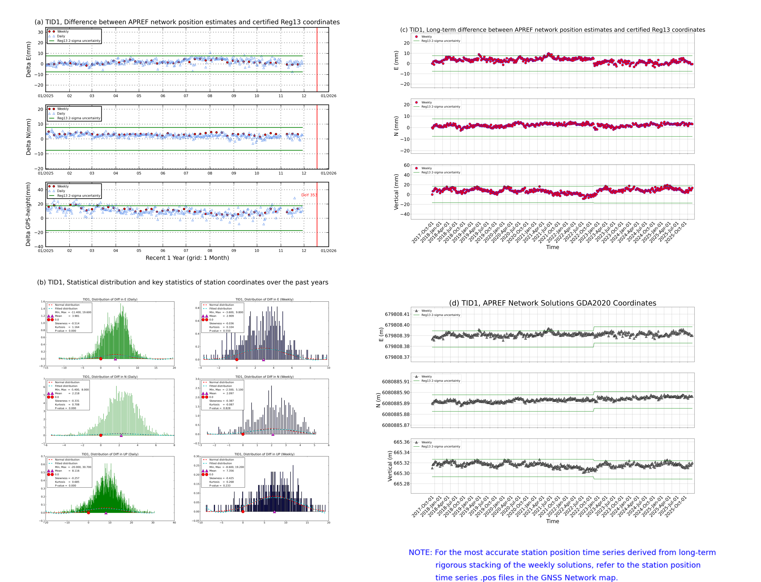

Note: The above graph indicates the long-term stability of a CORS and does not represent actual daily movement. The results are calculated daily and trends are monitored. The diagrams shown are updated regularly. Daily differences in CORS position at the millimetre-level are within the limits (noise level) of current GNSS processing techniques.