
DCS Spatial Services, on behalf of the Surveyor-General of NSW, actively manages the impact of survey mark destruction through the Preservation of Survey Infrastructure (POSI) program.
Survey marks form a key component in the State’s positioning infrastructure and provide a wealth of information to a range of people in the community. Often unnoticed, survey marks play an essential role in defining property boundaries and supporting billions of dollars’ worth of land investment and infrastructure development.
It is estimated that the unauthorised destruction and subsequent loss of survey marks costs NSW millions of dollars per year.* These costs are predominantly borne by landowners, government, developers, and the general community.
DCS Spatial Services administers the POSI program by:
- Actively engaging with relevant public authorities, developers, and stakeholders to promote POSI and raise awareness around survey mark destruction.
- Assessing statutory applications for the removal of survey marks to maintain the integrity of the State Control Survey Network and State Cadastre.
- Processing, adjusting, and reviewing POSI control surveys that contribute to the State Control Survey Network and update the Survey Control Information Management System (SCIMS).
- Undertaking audits and investigations into instances of unauthorised survey mark destruction.
- Developing resources, reviewing policies and standards to improve outcomes.
All development and construction work that may have an impact on survey mark infrastructure, must consider POSI and develop appropriate preservation and replacement strategies to mitigate any adverse outcomes.
Apply to the Surveyor-General to remove a survey mark
*Based upon cost of mark replacement and survey.
Importance of Survey Marks
The value of a survey mark generally relates either to its exact location, or its relationship to property boundaries. Survey marks are used for a variety of applications that are not always immediately clear. This can include:
- Surveying, GIS, and mapping,
- Engineering and construction.
- Town planning, transport, and asset management.
- Environmental and resource management.
- Land use (e.g., mining, agriculture).
- Spatially enabling different datasets.
Surveyors use survey marks to re-establish the accurate location of property boundaries giving confidence to landowners and other stakeholders. This information is recorded on a Deposited Plan, which constitutes the delineation of a property title and demarcates the boundaries of a land parcel.
Survey marks can also contain an accurate position and height telling users where exactly we are in the State, and how high or low we are located relative to sea level. This information is important for engineering, infrastructure development, mapping, flood studies, resource and environmental management, and other applications requiring a spatial component.
Types of Survey Marks
While a variety of survey marks can be used, they usually fall into two primary categories: Permanent Survey Marks and Cadastral Reference Marks.
Permanent Survey Marks are fundamental survey marks that define position and height for surveying, mapping, and engineering projects. Permanent Survey Marks are often found in roads, footpaths, kerb & gutters, or any natural ground surface.
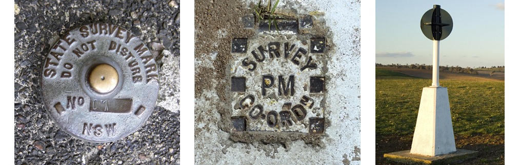
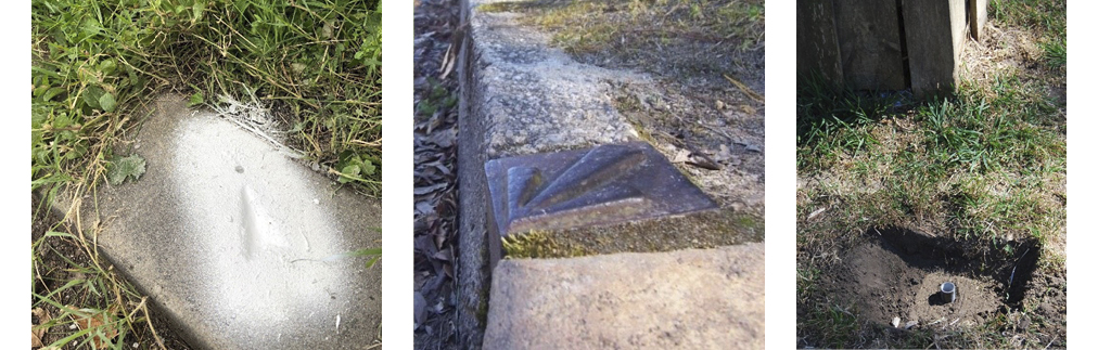
The second, more common category, are Cadastral Reference Marks which store the precise relationship to property boundaries. These survey marks can be found in a variety of forms including:
- Drill holes & wing chiselled into concrete such as in kerb and guttering.
- Alignment pins or stones placed at the intersection of a road or in a section of the kerb.
- Concrete blocks, iron rods or galvanised iron pipes buried in the ground nearby a property boundary.
- Reference trees that have been marked and blazed in rural environments.
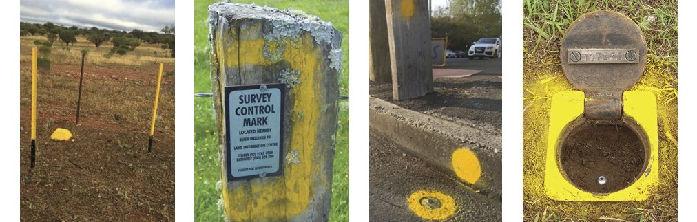
Surveyors often indicate the location of survey marks using star pickets, identification plates, or spray paint on surrounding features.
Why POSI is Important
The destruction of survey marks can weaken the integrity of property boundaries leading to a loss of confidence and the potential for disputes. Similarly, the loss of survey infrastructure and accurate positioning information, can lead to project delays and cost overruns.
Survey marks are usually destroyed by development activity or general land use, particularly:
- Infrastructure development including road, rail, and ports.
- Road works and footpath construction.
- General land use development including greenfield subdivisions, residential, commercial, and industrial property development.
- Underground utility upgrade or replacement including gas, water, electricity, and telecommunication cable installation.
- Roadside slashing.
- Street beautification projects.
Section 24 of The Surveying and Spatial Information Act 2002 prohibits the destruction, removal or alteration of any survey mark unless authorised by the Surveyor-General of NSW. Significant penalties apply,* including financial compensation towards loss or damage suffered and the costs of reinstating destroyed survey infrastructure.
DCS Spatial Services actively tries to manage the impacts of survey mark destruction by engaging with relevant public authorities, organisations, and stakeholders. It is critical that POSI is considered early on and throughout the project planning stage and should form part of the overall project strategy. Doing so minimises the risks of project delays and breaches of the Surveying and Spatial Information Act 2002 – both of which can significantly increase project costs.
*In addition to a maximum penalty of 25 penalty units (currently $110 per penalty unit) a person found guilty by a court may be ordered to pay compensation up to $10,000 towards the cost of reinstatement and up to $10,000 towards loss or damage suffered.
How to Safely Remove a Survey Mark
As a result of construction or development works, it may be necessary to remove some survey marks. DCS Spatial Services has developed guidelines and information packages to assist users in applying for the removal of survey marks and navigating the overall POSI process.
Surveyor-General’s Direction No. 11 – Preservation of Survey Infrastructure (SGD11) outlines the process and requirements that need to be met for the authorised removal of survey marks. It details the aims, procedures, and deliverables to follow to lawfully remove survey marks and preserve the valuable information these marks provide.
DCS Spatial Services categorises projects impacting survey infrastructure into either:
- Small scale,
- Large scale, or
- Mining.
This is dependent on the type of work involved, number of survey marks affected and the overall impact on the State Control Survey Network and/or State Cadastre. Specific procedures, deliverables and minimum notification times apply for each type of POSI application. Refer to the POSI Application Support Guide and the POSI Resource Pack for further information.
When undertaking works that may impact survey infrastructure, it is recommended to engage a Registered Land Surveyor as early as possible. Registered Land Surveyors are legally qualified to determine the location of a property boundary and have the necessary skills and experience to assist users in navigating the POSI process. To find a Registered Surveyor and to learn more visit the Board of Surveying & Spatial Information website.
Resources
Support guide to prepare a Survey Mark Removal Application
Surveyor General’s Directions No. 11 - Preservation of Survey Infrastructure
Documents and examples to assist with Survey Mark Removal Applications
Information Sheet - Protecting survey marks
Surveying and Spatial Information Act 2002
Surveying and Spatial Information Regulation 2024