
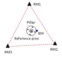
The CORS Reference Mark Survey (RM survey) involves periodic terrestrial monitoring of a CORS monument using at least three stable reference marks. The RM survey, which is undertaken for all Tier 2 AusCORS sites, involves both a horizontal and a levelling (EDM heighting) survey. In NSW, Spatial Services conducts these surveys during installation and then periodically thereafter.
This stability of Tier 2 CORS is vital as these sites are used for many precise scientific and research applications, such as tracking continental movement. The surveys achieve a precision of better than 1 mm in position and height and movement of as little as 1-2 mm may make the site unsuitable for such applications.
CORS RM surveys must be undertaken to specifications provided by Geoscience Australia, including the equipment used (precise and calibrated), the survey practice followed, and the data processing methods used.