On this page:
NSW Spatial Digital Twin
The NSW Spatial Digital Twin (SDT) is a program of work that is being led by DCS Spatial Services which will deliver a cross-sector, collaborative environment that will share and visualise location information, in a 4D model (3D plus time) of the real world, in near real time and will support improved decision making.
Spatial digital twins enable users to arrange large amounts of data in one place, to visualise the data in the form of 3D and 4D (3D plus time) models and to understand and analyse the data through detailed analytics. NSW’s Foundation Spatial Data provides the framework to deliver real-world context that enables users to make more informed decisions, saving costs and creating efficiencies.
At the heart of the NSW SDT is a shared data management and delivery platform that is open to the public and private sector allowing for effective collaboration to accelerate the deployment and uptake of smart and connected technologies across the state. It is central to planning, prioritising and delivering infrastructure more cost effectively and more quickly, while also ensuring community engagement.
The NSW SDT represents a step change in the way that government plans and delivers services to improve the lives of people in NSW and it will support NSW to be a state driven by data insights.
About the program
As part of the Live NSW program, funded through the Digital Restart Fund (DRF), the NSW SDT has been identified by Infrastructure NSW as an enabler of Smart Places and the realisation of the NSW Government’s priorities. It is a part of the future digital form of government which is citizen focussed and outcomes driven.
The program will:
- Deliver spatial data at quality and performance levels that generate savings and efficiencies right across government and industry.
- Specifically focus in the first four years on supporting infrastructure planning and delivery as well as emergency management.
- Provide opportunities for better support and decisions in relation to environmental management and natural resource management.
- Support effective and meaningful data analytics, and provide opportunities for collaboration across academia, industry, business, and government.
- Encourage and facilitate engagement between government and community to ensure better customer service.
The platform
The NSW Spatial Digital Twin is a cross-sector, collaborative digital workbench for whole-of-government use, that will visualise location information, in a 4D model of the real world (3D plus time).
Data is shared by data owners (data custodians) in the NSW Spatial Collaboration Portal, a secure platform that facilitates the delivery of NSW Government spatial datasets. The portal allows local, state, and federal agencies to deliver spatial data, asset management and enables the search and discovery of datasets for all NSW citizens.
Visualisation services for the NSW SDT are available to users either within the portal or through the Digital Twin Visualisation Service.
Telecommunications and utilities infrastructure in the Spatial Digital Twin
The NSW Independent Bushfire Inquiry on the 2019/2020 bushfires reinforced the need for telecommunications and utility infrastructure data, particularly spatial data that could inform risk and resilience decisions in the location and protection of essential utilities infrastructure in emergency situations.
The key objectives of developing a comprehensive telecommunications infrastructure data set are to:
- Improve the ability of Emergency Services Organisation (ESOs) to protect these vital assets through better understanding of their location, protection arrangements and interdependencies
- Ensure ESOs know what telecommunications services are and aren’t available to them for operational use, and understand what services are available to the community and
- Ensure communities have the greatest possible prospect of retaining communications and connectivity, allowing:
-
- people to be fully informed on fire progress and conditions
- people to call for emergency assistance
- people to communicate with family and neighbours
- government and ESOs to provide community warnings via emergency alert services
- access to post emergency services
DCS Spatial Services is currently developing a 3D spatial dataset of Government Radio Network (GRN) telecommunications towers and assets across NSW to assist with emergency management and response.
The project will scale to include all other telecommunications (Telco) utility asset data. In order to provide complete and current Telco data, access and sharing agreements are to be negotiated with Telco providers.
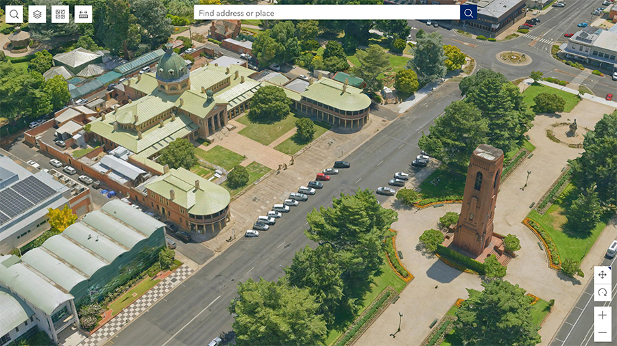
Bathurst Spatial Digital Twin
Bathurst has become the first regional city to be included in the NSW Spatial Digital Twin as part of the Live NSW program.
This digital representation of the city was delivered by DCS Spatial Services in partnership with Bathurst Regional Council and enables the visualisation of location-based information in 4D (3D plus time) of a 4,000,000 m² extent of the central business district.
Council, planners and the community can now interact with data in a user-friendly place-based platform enabling:
- Visualisation of location data including infrastructure and services such as bus stops, accessible parking spaces at a location, play equipment and off-leash dog parks
- Smart infrastructure, including Internet of Things (IoT) sensors, allowing access to real-time data for electric vehicle charging station locations and FuelCheck
- Visualisation of past, present and future built and natural environment to assist the council, developers and the community to collaboratively realise Bathurst’s best potential
- Support of the tourism sector by showcasing Bathurst’s unique architecture.
The Bathurst Digital Twin also showcases data provided by Bathurst Regional Council like accessible parking spaces, play equipment and dog parks. Further council data will be added as it becomes available.
As more data is integrated, the Bathurst Spatial Digital Twin is expected to provide significant opportunities for local councils and the NSW Government to realise benefits across the entire development and infrastructure lifecycle.
See the Bathurst Spatial Digital Twin here.
Tell us what you think
We would like to hear about your Bathurst Spatial Digital Twin experience. Your feedback will help us understand how the Bathurst Spatial Digital Twin meets your expectations as well as how we can improve it. Please access the Spatial Services Customer HUB here: https://www.spatial.nsw.gov.au/contact_us and follow the "Provide Feedback" link.