
July 2020
Spatial Services is delighted to announce the release of the second SPOT 6/7 imagery mosaic. This imagery, captured between January and April 2020, is part of the Spatial Services Whole-of-Government initiative to provide bi-annual, state wide, satellite imagery at 1.5m resolution.
As with the first mosaic captured in 2019, the provision of this dataset was awarded by tender to Geospatial Intelligence Pty Ltd who has partnered with Geoimage Pty Ltd and Airbus Defence and Space.
The imagery from the latest capture will be of use to agencies working on a range of change management initiatives. Used alongside our fourth quarter 2019 SPOT Imagery release it will be possible to:
- Monitor urban expansion and land use/cover changes at a small, medium or large scale
- Better observe and understand the evolution of urbanisation
- Better observe and understand advancing sustainable development processes
- View and compare bushfire affected areas throughout NSW prior to and post the devastating 2019/20 season.
What is SPOT 6/7 imagery?
SPOT imagery products offer high resolution over broad areas using the SPOT 6/7 satellites.
SPOT satellite acquisition covers large areas in a single pass at resolutions up to 1.5m. Such precise coverage is ideal for applications at national and regional scales from 1:250,000 to 1:15,000.
SPOT 6/7 also includes the benefits of the near-infrared (NIR) which enables applications for detection of features not visible to the human eye, such as detecting and monitoring vegetation health.
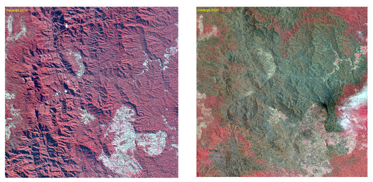
The above images are an example of how the NIR imagery (available within the mosaics) can be used to examine the damage caused by bushfires. Both images were taken over Cobargo, the left taken during the 2019 capture and the right taken during the 2020 capture. The vegetation shown in red is living and was not burnt by the fires. When contrasting these images, the extent of the damage caused by these recent bushfires becomes clear.
Available products
- Individual Mosaics/100K Mapsheet: Individual mosaics/ 100K Mapsheets from 2019 and 2020, available to NSW State Government agencies. BGR+NIR band combination, unenhanced 16-bit GeoTIFF format tile with an ESRI world file.
- State Wide Mosaic: RGB band combination, contrast enhanced lossless 8-bit JPEG2000 file with a world file. The 2019 capture and the 2020 capture are both available to NSW State Government agencies.
- Spatial Services NSW 2019 - Spot 6/7 State Coverage Web Map Tile Service (WMTS): SPOT 6/7 imagery as a state-wide mosaic in RGB, currently available as a basemap on the Spatial Collaboration PortalThe WMTS is OGC protocol compatible and suitable for consumption by common GIS platforms.
- Available soon - Spatial Services NSW 2020 - Spot 6/7 State Coverage Web Map Tile Service (WMTS): SPOT 6/7 imagery as a state-wide mosaic in RGB. The WMTS is OGC protocol compatible and suitable for consumption by common GIS platforms.
Who is Geospatial Intelligence?
Geospatial Intelligence is an Australian company committed to delivering high quality geospatial solutions to both the public and private sectors.
Geospatial Intelligence has considerable expertise in geospatial analysis, big data and link analytics, artificial intelligence, machine learning and the development of effective user interfaces. These skills allow users to develop sophisticated analytical tools that automate the extraction of information from large datasets and present this information in a format that supports informed decision making.
More information:
Geospatial Intelligence: https://geoint.com.au/
For more information, please contact us via our Customer Hub: www.spatial.nsw.gov.au/contact_us
Spatial Collaboration Portal (to view the 2019 mosaic as a basemap): https://portal.spatial.nsw.gov.au/