
Helping rebuild after the 2019/20 bushfires with spatial data
May 2020
The Service Point and NSW Point products from Spatial Services Administrative Spatial Programs team have been employed by Service NSW in helping small businesses impacted by bushfires get back on their feet. NSW Point validates addresses entered by applicants when applying for the Small Business Bushfire Support Grant, the Small Business Bushfire Recovery Grant as well as when registering for the NSW bushfire clean up service. Service Point interactive dashboards then enable Service NSW to spatially analyse the areas where registrations are being made and prioritise services in these areas
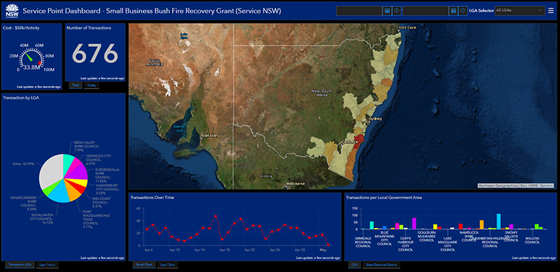
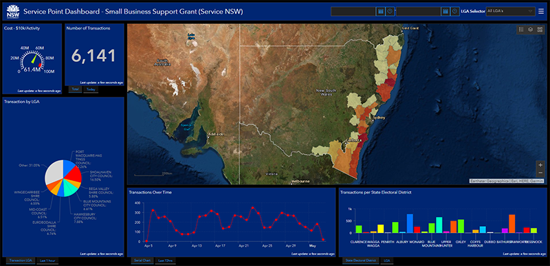
The Small Business Bushfire Recovery and Bushfire Support Grant dashboards which allow prioritisation of priority areasthrough spatial analysis of applicant locations.
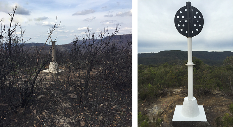
Survey Trig Station “Charles” (TS5899) damaged in the 2019/2020 bushfires, and after being restored by Spatial Services Survey Operations field crew.
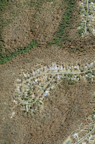
In addition to repairing the physical infrastructure in damaged areas, OSG field crews have been working to provide updated survey control in and around the towns of Balmoral, Buxton and Fitzroy Falls. By ensuring that the survey control data is up to date, surveying measurements taken from these points are current and take into account tectonic plate movement.
The updated survey control allows the Cadastral Spatial Programs development team to more easily complete much needed cadastral upgrade work. Spatially accurate cadastral (lot/deposited plan/strata plan) boundaries support and benefit property owners and local governments throughout the recovery period.
Spatial Services’ Cadastral Spatial Programs has accelerated this cadastre improvement process as a result of undertaking a review of bushfire impacted properties in NSW. Priority areas, requiring cadastral positional improvement were able to be identified after spatially analysing property boundaries, imagery and spatial accuracy vectors. The Cadastral Spatial Program development team is working in these priority areas to upgrade the Digital Cadastral Database (DCDB) boundaries.
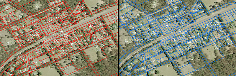
Before (red) and after (blue) cadastre upgrade in Wingello, NSW.
Imagery and LiDAR capture over impacted areas
Spatial Services Environment Spatial Program team has been working with key NSW government agencies since September 2019 to ensure they are adequately supported in their bushfire recovery efforts. Starting with the capture of airborne LiDAR and imagery for fire affected areas in Northern NSW the area of coverage was extended as the fires were gradually extinguished. The imagery and LiDAR captured in the wake of the bushfires has allowed for the massive geographic extent and impact of these fires to be mapped and documented.
The almost 50,000 square kilometres of bushfire affected areas across NSW has been marked to be captured by Environmental Spatial Programs aircraft, a Cessna 421c. The aircraft is in the process of capturing 50cm resolution 4-band imagery (RGB+NIR) which will initially be delivered as a rapid response product to better assist the recovery teams with timely data. A higher spatial accuracy and imagery quality product will be delivered later. Recovery teams from Department of Planning, Industry and Environment, Rural Fire Service and Local Governments, along with other state and federal agencies, are using the imagery to make informed assessments about where and how the fires affected communities, infrastructure and the environment. The imagery will have an extended role in assisting those communities impacted by the devastating fires to recover more efficiently.
 |
Examples of Near Infra-red (NIR) (left) and aerial (right) imagery over a bushfire affected area. In the NIR image, the red areas indicate normal, healthy vegetation, the surrounding areas indicate burnt vegetation.
Working with councils for recovery
Spatial Services is continuing to work closely with local governments and other state and federal government agencies to ensure critical areas are prioritised. Several local government areas already supported by updated Spatial Services spatial data and infrastructure include Wingecarribee, Wollondilly, Bega Valley, Shoalhaven, Eurobodalla and Bilpin (Blue Mountains) ensuring bushfire recovery works are effectively rebuilding these communities.