August 2021
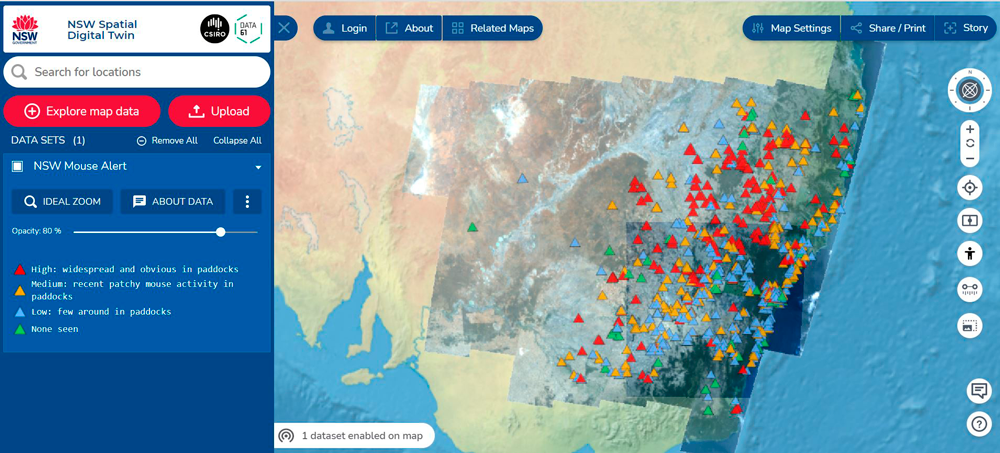
DCS Spatial Services has been working with NSW Department of Primary Industries (DPI) and CSIRO’s Data61 to bring new and very current mouse plague data into the NSW Spatial Digital Twin (SDT).
This is another great example of using SDT to deliver spatially enabled data of environmental significance to our state, making it accessible for all citizens.
Mouse numbers and locations are being reported by landholders across NSW through the MouseAlert application and website https://www.feralscan.org.au/mousealert/.
By making this data available on the SDT, it becomes more widely visible to citizens and encourages more community contribution which will both raise the profile of the application and the quality of the data.
This crowd-sourced data is very much user driven and, according to CSIRO, is considered quite an accurate indicator of the extent of mouse activity.
The MouseAlert app is able to deliver data through an application programming interface (API) feed of mouse locations and indices of activity. This data has been made publicly available and appears under live data and the attributes also contain a URL that will take the user directly to the MouseAlert website for the location and information about that report.
Complementary datasets of interest for mouse plague indicators include soil moisture, crop species and wind that all provide valuable information for landholders, industry, and government which support efforts to manage and control plague numbers.
From a scientific perspective, the data has limitations due to the nature of how contributions are made and the generalised way in which numbers are quantified.
Collaborative plans are in development to use sensor technology to monitor mouse plague activity in the future. Activity rather than mouse numbers are being targeted in this development which will leverage wireless technology that the agricultural industry is increasingly using to monitor localised weather conditions and soil moisture.
When landholders contribute their data to MouseAlert, they are connected to a suite for resources that includes support packages from DPI as well as Grains Research and Development Corporation videos and mouse plague information.
To access this new data on the NSW Spatial Digital Twin go to: https://nsw.digitaltwin.terria.io/, navigate to the top left hand side option Explore Map Data, choose Live Data, then NSW Mouse Alert in the drop down list.