
July 2020
DCS Spatial Services have been supplying fundamental positioning data in the new Geocentric Datum of Australia 2020 (GDA2020) since 2019, and have supported legislated changes to Survey Plans from 1 January 2020. We now are pleased to announce that the majority of our Foundation Spatial Data Framework (FSDF) data will be available from 1 July 2020 in both GDA94 and GDA2020 via the Spatial Collaboration Portal (SCP) in line with the national ANZLIC GDA2020 adoption date.
If you are new to using the SCP you will need to Create an Account and you may wish to review the How To Guides before delving into the data.
Our Spatial Data webpage provides a comprehensive list of available products, and instructions on how to access them. While we have focussed on suppling GDA2020 via our new SCP at this time, we also continue to work to provide additional GDA2020 products and services over the coming year.
Spatial Services will provide another update in December 2020 regarding availability of additional GDA2020 products and services. Please keep an eye on our website and LinkedIN in December for that update.
Please contact the Service Delivery Team via the Customer Hub with any questions.
Background: GDA2020 – The new datum
Australia sits on one of the fastest moving tectonic plates on earth, travelling almost seven centimetres north-east each year. To remain compatible with Global Navigation Satellite Systems (GNSS) such as GPS and to support high-accuracy positioning capabilities and their associated economic benefits, coordinates across Australia are being updated to account for this movement.
These critical upgrades to the Australian Geospatial Reference System (AGRS) are being made by the Intergovernmental Committee on Surveying and Mapping (ICSM). DCS Spatial Services is adopting GDA2020 as the first step in the process of datum modernisation.
From 1 January 2020, GDA2020 was adopted as the datum for NSW following amendments to the Surveying and Spatial Information Act 2002 and Regulation 2017 which commenced on that date. GDA2020 is now the prescribed datum for surveys carried out on behalf of the Surveyor-General or on behalf of other public authorities and is recommended for all other spatial information.
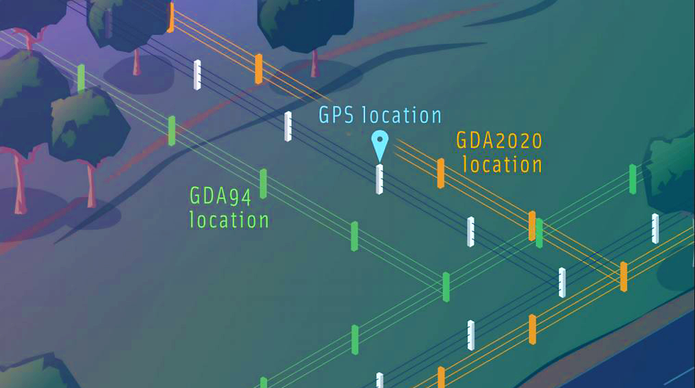
Coordinates are at best ambiguous unless they are linked to the related datum. Image credit: ICSM
GDA2020 & GDA94 – Transitioning to the new datum
DCS Spatial Services now provides authoritative datasets in the Geocentric Datum of Australia (GDA2020).
In addition, some DCS services continue to support requests for data in alternate datums until further notice. Users should still aim to update workflows to accept and/or transform GDA2020 data at their earliest opportunity.
There is currently no rush to transition internal data-stores to GDA2020, however data custodians should note that the ability to receive, consume and communicate a mixture of GDA94 and GDA2020 spatial information has become increasingly important as a result of the introduction of GDA2020. The transition to this new multi-datum environment has highlighted limitations in current spatial data management systems, particularly regarding misalignments resulting from the use of WGS84. These issues are currently being addressed through updates to international standards and software and are discussed in more detail in a national advisory on WGS84 and web mapping.
One significant implication of these limitations in software is that DCS Spatial Services web services, including tiled services such as Imagery and Basemaps are not yet generally available in GDA2020.
Users are recommended to anticipate and prepare for increasing availability of GDA2020 during 2020/2021 as solutions to the above issues are rolled out through software, and DCS Spatial Services web services become available. DCS Spatial Services will keep users and data custodians aware of these updates through regular communications and updates of the Spatial Data webpage.
The transition to GDA2020 will also require data custodians to transform their own existing datasets and workflows. Whilst Spatial Services will be supporting and supplying data in both GDA2020 and GDA94 over the next three years, we cannot provide transformation services for your existing datasets. Please contact your existing GIS or software provider for guidance and support.