
December 2020
DCS Spatial Services has collaborated with Geoscience Australia from 2017 onwards to deliver NSW elevation and depth data through the online ELVIS platform.
Elevation and depth is the measurement of the earth’s surface above or below a vertical datum and forms one of 10 themes in the NSW Foundation Spatial Data Framework (FSDF). The FSDF is supported by ANZLIC, the organisation that provides leadership in spatial information across Australia and New Zealand and provides a common reference for the base and spatial (foundation) datasets that are the most current, authoritative source of spatial information.
As the first jurisdiction to join forces with Geoscience Australia, ELVIS provides a platform for DCS Spatial Services to offer valuable high-resolution elevation and depth information, including point clouds (LiDAR) and 5 m, 2 m and 1 m multi-resolution digital elevation models (DEMs). The availability of this information has eliminated government duplication and reduced costs associated with data acquisition, it also allows users to discover open datasets in one location.
Quarterly information is supplied by ELVIS which compares monthly orders across NSW jurisdictions. In September 2020, ELVIS hit a new record of 10,408 data orders with no sign of growth in demand slowing down. This was 50 per cent growth on the same period for 2019, with DCS Spatial’s data almost matching Geoscience Australia’s data downloads and exceeding all other jurisdictions in Australia. In September, 2,008 orders were submitted for DSC Spatial Services’ 1 metre DEM data, making it the second highest request on the ELVIS platform after Geoscience Australia’s DEM’s. DCS Spatial Services’ Point Cloud data also ranked fourth with 1,118 orders.
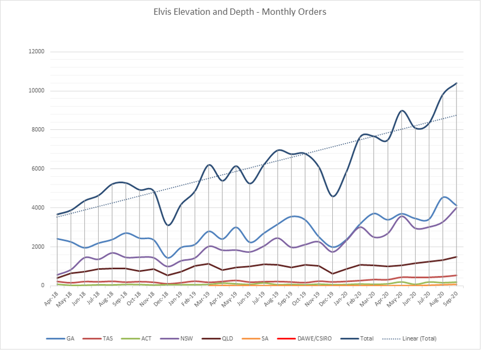
Figure 1: ELVIS month on month data orders (Geoscience Australia, 2020).
These reports demonstrate the wider spatial community’s need for and consumption of data produced by DCS Spatial Services elevation program in collaboration with Geoscience Australia. Committed to delivering real value to industry, DCS Spatial Services strongly supports the engineering, energy and environmental sectors as well as other government agencies. Elevation and Depth data is used across all sectors of the natural and built environments, economy and society and can be applied to many areas to deliver improved outcomes.
To access Spatial Services through the ELVIS platform please visit https://elevation.fsdf.org.au/
Imagery and LiDAR capture supporting bushfire recovery
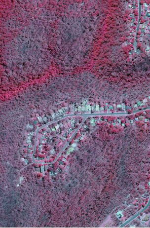
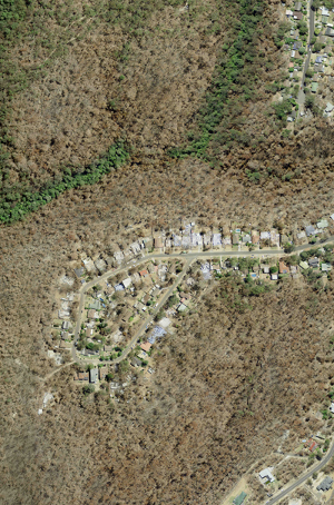
DCS Spatial Services’ Environmental Spatial Program team has been working with key NSW Government agencies to ensure they are adequately supported in their bushfire recovery efforts since the end of the 2019/2020 bushfires. The imagery and LiDAR captured in the aftermath of the bushfires enabled the massive geographic extent and impact of these fires to be mapped and documented. Recovery teams from Department of Planning, Industry and Environment, NSW Rural Fire Service and local governments, along with other state and federal agencies, are using the imagery to make informed assessments about where and how the fires affected communities, infrastructure and the environment.
Over the past 12 years, 50 cm digital 4-band imagery acquisition has been an ongoing program of work for the Environmental Spatial Program team. This substantial undertaking culminated in full state coverage being available from 21 May 2020. The imagery team had a massive job of capturing and processing which included; 4,790 individual flight lines of 285,580 linear kilometres, processing more than 7 trillion pixels, editing over 700,000 km of seam lines and producing 344 current layer map sheets of imagery covering over 800,000 km² of NSW.
 |
 |
Where to now
The State Infrastructure Strategy called for the development of a business case for an upgrade of the NSW’s Foundation Spatial Data Framework (FSDF) from a two-dimensional map to a four-dimensional model (3D + time). That is a full three-dimensional model of the state’s physical environment, capable of recording past conditions and visualising future scenarios. Four-dimensional models of this nature are increasingly referred to as digital twins.
While this was the primary driver for the development of the NSW Spatial Digital Twin, the recent NSW Independent Bushfire Inquiry recommendations also identified the need for significant improvements to the range, quality and timeliness of imagery provision for emergency management. In addition, there is a requirement to develop a simple, rapid and repeatable imagery processing pipeline that minimises the period between acquisition and operational provisioning. The scope covers:
- Satellite imagery
- Aircraft imagery
- Remotely Piloted Aircraft (RPAs)
- Terrestrial (vehicle and stationary)
The scope also covers a range of data types, including multi-spectral, SAR, and LiDAR.
The proposed outcome of this project is to provide an automated, efficient, repeatable Whole of Government imagery and elevation acquisition, processing and delivery pipeline that supports a broad range of end user requirements.