
On this page:
- Introduction
- Vector versus raster
- Vector basemap styles available
- Where to access new basemaps?
- Copyright and terms of use
- Related links
- Contact us
- Testimonials
Introduction
New NSW basemaps are here! These restyled and digitally enhanced basemaps provide a suite of functional, intuitive and authoritative foundational datasets for deployment within a variety of GIS web applications. The new basemaps deliver high-level precision accuracy for geospatial intelligence operations.
Basemap solutions are designed to provide a foundation for users to underpin their own data with our services. Each new vector basemap has its own unique way of visualising data. This will help to improve the way NSW is presented on a map and provide opportunity for greater customisation.
Older versions of the raster-style basemaps remain available in our platforms for our customers and are still widely utilised for analysing data including, elevation, depth and more broadly, storing aerial and satellite imagery information. These basemaps are accessible via the ‘NSW Map Viewer’ which can be found here.
This upgrade supports a significant technological expansion within DCS Spatial Services and will underpin spatial initiatives across NSW Government, industry, academia and will benefit the public.
Click here to start exploring NSW basemaps today
Vector versus raster
Vector
Vector data stores basic geometries (made up of one or more interconnected vertices), with three key types:
- Points - single vertex, for example, a house.
- Lines - two or more vertices where the first and last vertex are not equal, for example, a road.
- Polygons - three or more vertices with the last vertex equal to the first, for example, a boundary.
As opposed to raster basemaps that use cached images, vector basemaps render cached layers dynamically and are symbolised by an accompanying style file. Consequently, vector tiles have numerous advantages over traditional raster tiles, including significantly smaller file sizes, better interoperability and high-resolution display at various scales.
Raster
Raster data imagery is made up of pixels suitable for larger file sizes. Raster files can become distorted or blurry as the file is manipulated, for example, zoom in or out.
Vector basemap styles available
The complete set of new basemaps include:
A brief introduction to a sample of the new basemaps outlined below:
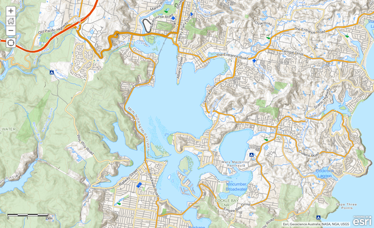
Topographic style (non-relief and relief)
Below is a Topographic (relief) map, which captures roads, terrestrial water bodies and vegetation. Additionally it illustrates the hill shade layers to depict the contouring, elevation and depth of the surrounding landscape.
Note: at present, dynamic rotating labels are not a feature within the ‘panning’ function of our maps. However, this and other enhancements are part of future developments.
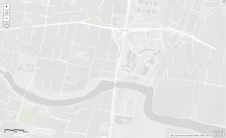
Light grey canvas
The restyled light grey canvas basemaps are an excellent way to accentuate any desired thematic using neutral tones and a minimalistic feature layer set. Only the key information is represented to clearly illustrate geographic context, enabling datasets to be more prominent on the map.
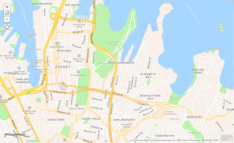
Navigation
The enhanced navigation basemaps are designed to ensure a seamless user experience, offering a mobile friendly design and high-resolution display.
These new navigation maps display the standard features expected on any modern digital street map and include buildings, water features and administrative boundaries.
Where to access new basemaps
The new basemaps options are available in our online viewers, for example, the Spatial Map Viewer as a web map service. Select your preferred option to then import your own data to create a custom view.The vector basemaps can be accessed by API to utilise in your own GIS software, providing NSW FSDF (Foundation Spatial Data Framework) data from the authoritative NSW source.
Copyright and terms of use
DCS Spatial Services provide a range of datasets to private and government clients under Creative Commons licensing, in line with the NSW Government and NSW Department of Customer Service Open Data Policy. Read more about DCS Spatial Services copyright and licensing information here. By accessing any of the available Spatial Web Services you acknowledge acceptance of the Terms and conditions.
Related links
https://data.nsw.gov.au/data/dataset/nsw-basemap
https://www.spatialsource.com.au/new-basemap-options-coming-for-nsw/
Contact details
If you have any questions or feedback about basemaps or require further information, please contact the Spatial Services Customer Hub.
Testimonials
“Beautiful basemaps! I just wanted to pass on praise for the excellent selection of vector tile basemaps. Our solution engineering team are very impressed. I am torn between topographic and greyscale for a favourite. Congratulations, I am looking forward to using these.” Simon Jackson – Esri- 12th September 2022